Star treks: Vancouver’s best hikes for all levels

Roula Khalaf, Editor of the FT, selects her favourite stories in this weekly newsletter.
This article is part of a guide to Vancouver from FT Globetrotter
There are hikers — a trekking pole gripped in each fist, backpack bulging with extra clothing and protein bars, sturdy boots laced tightly over thick socks — and then there are people who, occasionally, when the weather is right and the mood strikes them, like to go for a hike.
I’m in the latter camp at home in Vancouver and when travelling, and my guiding question when deciding whether to go for a hike and what route to choose is this: can I do it in my regular running shoes, perhaps while dressed for a casual coffee before or lunch and a craft beer afterwards?
People who like to hike in this chill, very-Vancouver way are spoiled for options here. And while the city is known for its stunning views of the majestic North Shore mountains, taking to the trails often means giving up these spectacular vistas for smaller, more intimate treasures: trickling streams, towering trees, forested lookouts and cool, fresh air.
Both in Vancouver proper and its surrounding cities (that are within easy striking distance of the downtown core), there are opportunities aplenty for relaxed hikes that require no special equipment — just the desire to step off paved paths for something greener.
Safety tips
Just because you’re not heading into a vast, uncharted wilderness doesn’t mean you should leave common sense behind. (And if you are planning a different route well off the beaten path, make sure to consult North Shore Rescue’s 10 essentials checklist.)
Wear supportive footwear (no flip-flops), carry water and dress appropriately for the weather. For large chunks of the year in Raincouver, you’ll need both wet-weather gear and sunglasses, and a cap for shade and/or to keep raindrops off your face.
Also, make note of the nearest craft brewery. The Metro Vancouver area is full of them, and if you’re going to exercise, you might as well reward yourself.
Quarry Rock Lookout (4km, 100m elevation)

Good for: A hike-and-talk with friends
Not so good for: Someone who doesn’t like heights, because the pay-off at the top of the trail is a panoramic view from high above Burrard Inlet
Will you sweat? Almost certainly, because there are some steeper inclines that, while easy to walk, still require exertion
FYI: Parking is at a premium and recent roadworks have limited where you can drive and park. The transit service from downtown Vancouver to Deep Cove takes about an hour, or consider taking a taxi or using a ride-hailing service — and go midweek if you can

Deep Cove is a village located at the eastern edge of North Vancouver that slopes down towards the shores of Burrard Inlet. A five-minute stroll from its petite high street, to the top of Panorama Park, is the entrance to the trail that leads to the Quarry Rock Lookout.
The trail starts with a series of steep wooden steps that eventually lead to a combination of cleared trails (that are nonetheless pocked with rocks and tree roots) as well as wooden walkways, short bridges and more steps. The entire route is shaded by trees until the lookout, at the end.
You’ll usually have plenty of company as Quarry Rock is a popular destination for locals and travellers alike; on a recent weekend-morning trek, there were families, couples, friends and plenty of dogs.

The round trip takes about 90 minutes, but the lookout at the turnaround point makes the time and effort worthwhile: from a massive stone outcrop, hikers can enjoy expansive views of Deep Cove below, with its waterfront homes and array of boats floating in marinas; of the forested waterfront village of Belcarra across the water; and Simon Fraser University atop Burnaby Mountain. On a clear day, there’s mountain and water for as far as the eye can see.
After the hike, for a reward, head to Honey Doughnuts on the tiny main drag in Deep Cove, for fried balls of sugary goodness the size of your fist — and a reputation as a favourite spot of Kate Winslet. You’ll easily spot it because of the queue.
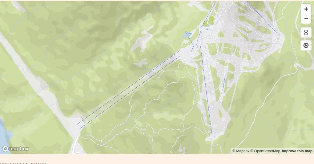
The Grouse Grind (2.9km, 800m elevation)
Good for: A fitness challenge
Not so good for: A leisurely walk in the park
Will you sweat? Absolutely — just ask the professional athletes who use the Grind as part of their off-season training routines
FYI: The hike up is free but the ride down, on the Grouse Mountain Skyride gondola, costs C$20 per person (and you must ride down as the Grind is one-way). The trail recently closed for maintenance works, which are expected to be complete by the end of the year
Open from spring through autumn (weather permitting), the Grouse Grind is billed as “Mother Nature’s StairMaster” for good reason. It takes 2,830 steps to ascend from its entrance at the Grouse Mountain parking lot in North Vancouver to the top of the trail, where hikers are rewarded with stunning east-west views of Vancouver, including downtown and Stanley Park. The journey uphill takes an average of 2.5 hours “for those with a good level of fitness” (the fastest person to complete the Grind did it in 23 minutes, 48 seconds.)

Clearly, the Grind isn’t for everyone, but it attracts thousands of relatively fit visitors looking for an alternative to sweaty hotel gyms. Locals also flock to this route in the tens of thousands annually, and some would argue you’re not a true Vancouverite until you’ve done the Grind (and bragged about it on your social channels).
Grouse Mountain’s FAQ will address most of your queries about hiking the Grind but here are some quick points to consider: keep to the right, pass on the left; bring food and water; leave no litter; access bathroom facilities at the bottom and top because there are none on the route; and dress for the weather. While Grouse recommends trail shoes or light hiking boots, many people do the Grind in trainers.

When you reach the top of the Grouse Grind, you can visit the resident grizzly bears, Grinder and Coola, at the Grouse Mountain Refuge for Endangered Wildlife (check them out on webcams ahead of time) or, if you’re not sufficiently tired, you may want to try the Mountain Zipline Tours. You could also stop for a coffee or bite at one of the eateries atop Grouse, or enjoy a BeaverTail — hand-stretched, wholewheat, deep-fried pastries served with sweet toppings.
Then, satisfied with your accomplishment (or calorie replenishment), revel in the almost silent ride down in the gondola with a sprawling, magical view of Vancouver.
Stanley Park (27km of walking trails in total)

Good for: Avoiding crowds in this popular park when it’s warm. (Most people tend to cluster near the waterfront, while the hiking trails are deeper within the park)
Not so good for: Working your cardio. It’s mostly flat and the routes aren’t particularly challenging
Will you sweat? Probably not most of the year, unless you decide to jog
FYI: Rawlings Trail, the park’s longest, is named after WS Rawlings, Vancouver Parks Board’s longest-serving superintendent (1913-36)

Most visitors to Vancouver’s largest and most beloved park focus on its outside edges: the 10km seawall, the beaches, the stunning ocean and mountain views. But the trails that criss-cross the centre of Stanley Park offer respite from the busyness around it.
While the paved seawall is a flat, scenic and often crowded route around the park’s perimeter, the wide gravel or bark-mulch trails allow you to traverse the city’s green gem amid the solitude of the trees, some of them hundreds of years old. About 27km of trails take hikers away from the crowds, and even when it is hot and sunny, they remain cool and quiet — or, during one of Vancouver’s frequent rainy days, they are more sheltered from nasty weather. Walk these flat or gently sloped trails and you may encounter joggers or cyclists, but there’s space for all users even in the peak tourist season.

You can wander the trails from a variety of access points all around the park and choose which one you’d wish to do. There are many trails, of varying lengths, offering hike options from about 30 to 90 minutes. Some eventually reach the waterfront; the south-west end of the Bridle Path, for example, pops you out at Second Beach, which has a large outdoor swimming pool (open in late spring and summer) and concession stand. To make the most efficient use of your time, you can access the Stanley Park trails map online, though if driving into the park, I might suggest parking at Prospect Point, then heading south on the trail of the same name before connecting with the Bridle Path, and looping back via the Rawlings Trail. If walking into the park from the West End, you could do this in reverse: either Bridle or Rawlings to Prospect Point, then looping back on the other. Taken at an easy pace, this would probably take over an hour.
Hiking the well-signed routes, you’ll read names that are a nod to the park’s past — Rawlings, Tatlow, Thompson among them — with some in memory of parks board officials from the 1800s and early 1900s. However, as Stanley Park is on the unceded territories of the Musqueam, Squamish and Tsleil-Waututh peoples, and villages there were occupied for thousands of years by First Nations, you’ll also see flags representing those Indigenous peoples flying at Brockton Point, in the eastern portion of the park.
And if all that peace and quiet are too much and you need a respite from the respite, stroll into the West End, where busy Denman and Davie streets offer bars, restaurants and shopping.
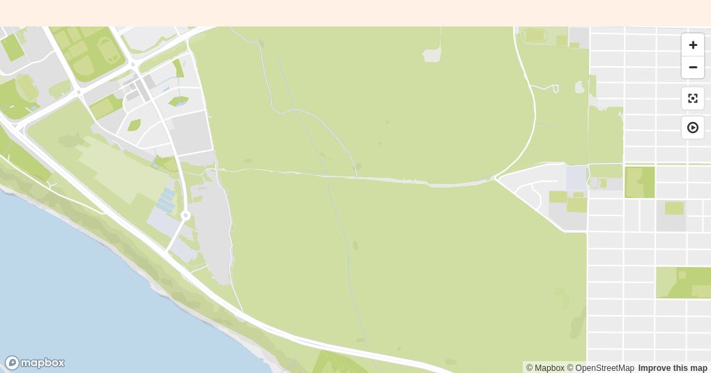
Pacific Spirit Regional Park (55km of walking trails in total)
Good for: A hike, a jog, meeting dogs
Not so good for: Solitude — these trails are well used by hikers, dog walkers (with pooches off lead, where it’s allowed) and, on some routes, cyclists
Will you sweat? During warmer parts of the year and if you set a quick pace
FYI: Located close to the western tip of Pacific Spirit park and the University Endowment Lands is the clothing-optional Wreck Beach, at the bottom of Trail 6 and reachable by trails and stairs

Where you end up depends on where you begin in Pacific Spirit Regional Park, which is located within the University of British Columbia’s Endowment Lands. There are three portions of park: a large chunk east of campus facing north towards the mountains; an even larger section, also to the east of the university, that faces south towards the Fraser River; and a skinny strip that runs like a layer of icing around the affluent residential area of West Point Grey on the south, west and north sides.
Hike the trails of the slender strip and you might end up on a beach such as Acadia, Tower or the clothing-optional Wreck. Ramble through the large northern chunk and you may find yourself surrounded by some of British Columbia’s most expensive real estate or heading towards Spanish Banks, another popular and easily accessible beach. Take on the largest portion of the park and you’ll cross Musqueam or Cutthroat creeks, skirting a dense ecological reserve that is closed to the public, and you’ll walk the wide, well-used network of trails with names such as Powerline, Hemlock, Imperial, Salish and St George’s, the latter sharing a name with a posh private boys’ school nearby. One possible route of about an hour would start on Camosun Street, where you can step on to the westbound Sasamat Trail, eventually connecting with Powerline Trail and heading towards its western end before turning north along any number of connecting trails — Salish, Iron Knee, Sword Fern — then eventually looping back towards Sasamat via Council or Hemlock.


Trails are well marked and signed maps are available, as are toilets, and some of those trails will take you to the UBC campus, which comprises nearly 400 hectares and is attended by some 60,000 students. The easiest way to navigate the park is to access a brochure online that includes maps of each of its sections.
If your hike should take you to Wesbrook Village, a housing and commercial development in the south-eastern portion of the university lands, and you’re feeling peckish, you could do worse than visiting Doughgirls Comfort Kitchen and Bakeshop for coffee, tea and treats both savoury and, like the end of a strenuous hike, sweet.
Other hikes and resources
According to Stephen Hui, author of a number of books about hiking in British Columbia, including 105 Hikes In and Around Southwestern British Columbia and Best Hikes and Nature Walks with Kids, here are three more relaxed hiking suggestions in Metro Vancouver:
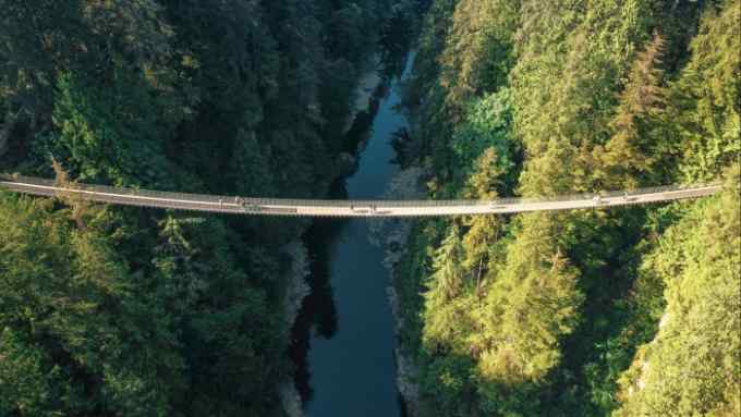
Lynn Canyon Park, North Vancouver — a suspension bridge, plunging waterfalls and tall conifers (20-30 minutes from downtown Vancouver; directions)
Sasamat Lake, Belcarra Regional Park — a pleasant hike among the trees no matter what the weather (45 minutes from downtown Vancouver; directions)
Burnaby Mountain, Burnaby — a high point (literally) in Metro Vancouver, Burnaby Mountain is home to both Simon Fraser University and a network of up-and-down trails (30 minutes from downtown Vancouver; directions)
Share your favourite Vancouver hikes in the comments below. And follow FT Globetrotter on Instagram at @FTGlobetrotter
Cities with the FT

FT Globetrotter, our insider guides to some of the world’s greatest cities, offers expert advice on eating and drinking, exercise, art and culture — and much more
Find us in Vancouver, Copenhagen, London, Hong Kong, Tokyo, New York, Paris, Rome, Frankfurt, Singapore, Miami, Toronto, Madrid, Melbourne, Zürich and Milan

Comments