Toronto trails: explore the city in four 5k runs

Roula Khalaf, Editor of the FT, selects her favourite stories in this weekly newsletter.
This article is part of a guide to Toronto from FT Globetrotter
Let’s get one thing straight from the start: I hate fitness trackers. Apple Watches, Fitbits, Strava: they can all go in the bin as far as I’m concerned.
Even on my weekly jog with my best friend, when she pauses her Strava for a bit of chat at the traffic lights or makes us keep going an extra 200 metres to reach the full kilometre, I want to jump in a canal.
The problem with all these gizmos measuring minutes and miles is that they make running just another part of the rat race, rather than what it can be: a blessed escape from our often competitive and helter-skelter lives.
Toronto, with its sparkling waterfront, leafy neighbourhoods and hidden ravines, is the perfect city for a runner who would rather be an explorer than a hamster on a wheel. This freedom is the merit of running, especially for a traveller. You can do it just about anywhere, as long as you’ve got shoes and a sense of direction.
The winter, of course, is a major drawback of jogging in Canada’s largest city. If you’ve never tried cardio in sub-zero temperatures, I honestly can’t recommend you start now. Your lungs can thank me later. So in the depths of winter, you may have to give in to the banality of life and run on a treadmill. But that still leaves plenty of months to enjoy the outdoors.
Left to my own devices, the length of these running routes would be “as long as I felt like going that day”. But my editor tells me 5k is the standard so I’ve done my best, give or take 200 metres.
Waterfront (2.7km)
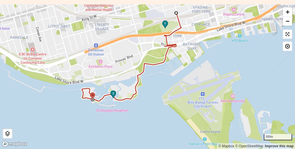
Good for: Flexibility. Toronto’s waterfront is a runner’s delight, with miles of continuous trails strung through the parks and marinas that line the shores of Lake Ontario, one of the world’s largest freshwater lakes. You can join the trail wherever is convenient and easily make your own route
No so good for: A quiet jog. The waterfront is always pretty busy and often hosts major events in the summer that draw crowds
FYI: The trick of accessing the lakefront is to get past the huge railway and highway corridor that cuts it off from the rest of the city (an original sin of urban planning for which Toronto has yet to atone). Only certain roads and pedestrian bridges actually cut through to the water
Directions on Google maps
Download this route (GPX file is compatible with most popular running apps)
This route takes a detour from the main east-west shoreline trail for a less busy path with brilliant views over the lake and back towards the city. On a clear day, from the top of the city’s skyscrapers, you can see New York State on the other side of the water. But from the shoreline, the view is an uninterrupted blue horizon.

Start at Stackt Market (Front Street West and Bathurst Street), where Toronto has caught up with the trend of piling some shipping containers on top of each other to create a trendy food, drink and retail space. Running south over the bridge, you have the best view of Fort York, the colonial-era British bastion, dating from 1793 and once the military centre of the city (called York until 1834).

Passing under the elevated expressway, you’ll run through The Bentway, an events site that periodically hosts art installations, and then a short distance through the streets to reach the waterfront park. Follow the shoreline along the south side of a series of linked artificial islands that form Ontario Place, a 1970s events venue (which looks a bit like a crashed space station). Indeed, most of the land south of Front Street was reclaimed using landfill in a massive operation beginning in the 1920s. The park provides a natural loop at the end of this route to send you back the way you came, with even better views on the trot home.
Brickworks/Don Valley (4km)
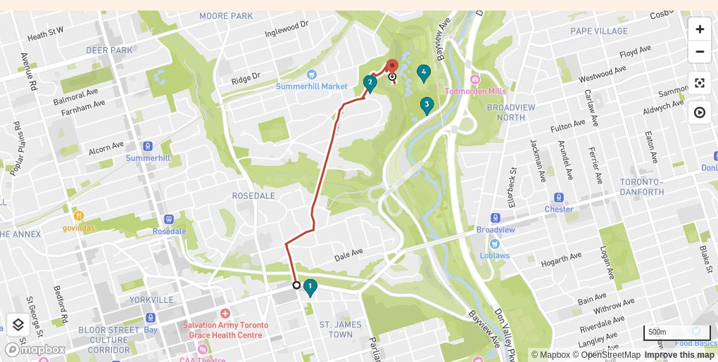
Good for: The urban wilderness. In the Don Valley ravine, it’s easy to forget you’re in the middle of a city of 6mn people
Not so good for: Beginners. This route tackles several daunting hills
FYI: Toronto is, on the whole, a very safe city but the usual rules of urban prudence apply. Ravine routes are safer avoided after dark
Directions on Google maps
Download this route (GPX file is compatible with most popular running apps)
There are several routes into the Brick Works parkland but, if you’re coming from the city centre, the easiest way is to run up through the leafy streets and stately brick homes of Rosedale, Toronto’s poshest residential district. On the way, you’ll cross two substantial bridges over the deep, verdant watercourses (Torontonians tend to call them ravines) that made this area a desirable enclave.
The entrance to the parklands is via Chorley Park, former site of the palatial residence of the Lieutenant-Governor of Ontario, local representative of the monarch. Today, only a forlorn plaque and the outline of the driveway remain of the mansion, which was closed as a gesture of austerity in the Great Depression and later demolished.

Down in the valley, the restored Brick Works are a picture postcard of post-industrial regeneration. On my early-morning visit, the scenic park was full of retirees walking their dogs and platoons of backpack-sporting children embarking on their day’s summer-camp adventure. (One earnest youngster stopped me to make sure I didn’t step on a precious caterpillar.)

It is worth sweating up the hill for the view over the Brick Works and valley back towards the city, much of which was built from red bricks pressed in this factory over almost a century before it closed in 1984. You can stop by one of the cafés or bakeries to gather your strength before tackling the switchback path back out of the valley to complete the route.
Casa Loma (4.64km)
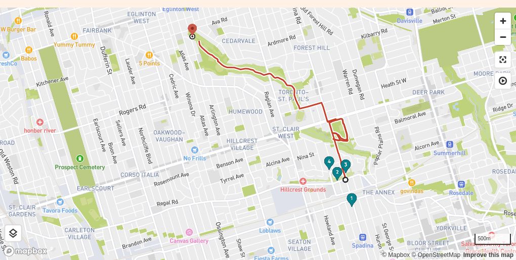
Good for: Combining running with sightseeing and a panoramic view
Not so good for: The giant flight of steps you have to climb to reach the view
FYI: For a public transit option, start from Dupont station, a few hundred metres south of the Baldwin Steps
Directions on Google maps
Download this route (GPX file is compatible with most popular running apps)
Dedicated athletes can start this route with a bang by charging up the 110 stairs to the top of the bluffs that once formed the shoreline of a prehistoric lake. I prefer to walk. The view south over the city from the top of the steps is worth the sweat.


To one side, at the top of the steps, is Spadina House, once home of the Baldwin family (a local political dynasty) and then the late-19th-century businessman James Austin and his descendants. It’s now a very charming museum. Opposite is the much showier Casa Loma, completed in 1914 by Sir Henry Mill Pellatt, a sort of Canadian robber baron who brought hydroelectricity to Toronto from his generating station at Niagara Falls. The costs of the faux-castle proved unsustainable for Pellatt, and it has been a financial albatross ever since. But you can still enjoy the fairytale façade as you jog by — and it’s worth a detour to see the equally elaborate stables, also accessed via underground passage from the castle.

The view here is most remarkable for what you are not seeing, a six-lane highway that was planned in the 1960s to cut all the way down Spadina Avenue. The expressway plan was blocked by local resistance organised by the American-born urbanist Jane Jacobs, now hailed as something of a folk hero by residents in the charming neighbourhoods that were saved from destruction.
The remainder of the route takes you through another set of verdant ravines, and around the delightfully airy circular track on top of an underground 220mn-litre reservoir built in 1931, which provides water to a large chunk of the city.
The University (2.7km)
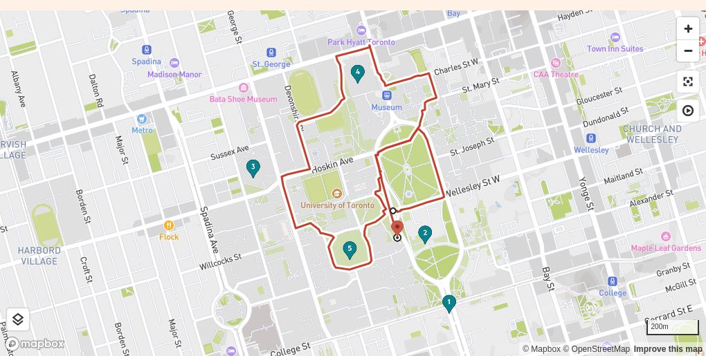
Good for: An evening jog. The route is well lit and usually bustling
Not so good for: At certain hours you’ll be swept up in tidal waves of students rushing across the vast campus to their lectures
FYI: The university is in the middle of a titanic construction project to create underground parking. Expect disruption
Download this route (GPX file is compatible with most popular running apps)
This run begins and ends with a lap of the track behind Queen’s Park, the seat of the provincial government. First-time visitors might want to expand the loop to take in the front of the impressive Romanesque block of pink stone. Pass under a bridge to enter the campus of the University of Toronto (my alma mater), which has grown from a provincial religious college to a research powerhouse that gave the world insulin and has now educated almost 100,000 students.


Unlike the cohesive campus design of some American universities (think Columbia or the University of Virginia), U of T has sprawled over time, leaving visitors with something like an architectural tasting menu set around a number of irregular lawns. Sample styles from the Neo-Gothic Hart House and Soldiers’ Tower to the Romanesque Revival University College, 1960s Massey College and the monumental Brutalist library (does it look like a peacock or a turkey? Scholars debate to this day). You’ll also pass one of the city’s most controversial architectural features, the glass and steel “crystal” exploding out of the side of the venerable Royal Ontario Museum.
We’re trialling new interactive maps and would appreciate your feedback. Let us know what you think in the comments
Cartography and development by Serena Chan, Mark Limb, Kristo Mikkonen and Ændra Rininsland
Follow FT Globetrotter on Instagram at @FTGlobetrotter


Comments